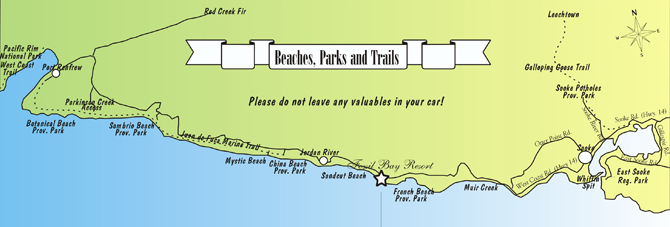
. . . west of Fossil Bay Resort
2 km - Sandcut Beach
Sandcut Beach is on the east end of
Jordan River Regional Park.
A 10 min. walk through the rain forest leads to a sand and pebble beach with waterfalls and sandstone rock.
6 km - Jordan River
The west end of
Jordan River Regional Park,
a pebble beach right along the highway is popular with surfers and kayakers.
10 km - Juan de Fuca Marine Trail
The
Juan de Fuca Marine Trail
starts from the China Beach parking lot. The
47 km hiking trail
along the Pacific coast line ends at Botanical Beach and offers rugged beauty and wildlife viewing.
10 km - China Beach Provincial Park
A 15 min. walk through lush West Coast rain forest gives access to beautiful sandy
China Beach.
12 km - Mystic Beach
2 km past China Beach, just before the second bridge, parking on the roadside or on a small parking lot
on the other side of the bridge, no signs. A steep 30 min. forest trail ends on an attractive sand beach
with sandstone cliffs, shallow caves and waterfall. This beach is also accessible via the
Juan de Fuca Marine Trail.
28 km - Sombrio Beach
Sombrio Beach
is popular with surfers taking advantage of the huge breakers coming in from the ocean.
A winding gravel road (1.7 km) leads to a parking lot and a 10 min. walk to a sand and pebble beach.
39 km - Parkinson Creek
Turn left on the access road (3.8 km) to the
Parkinson Creek Trailhead.
The seal caves west of the mouth of the creek are accessible from the beach during very low tides.
51 km - Botanical Beach Provincial Park
Follow the road to the very end, turn left past the Lighthouse Pub - 3 km ahead is the parking lot.
A 15 min. walk from the parking area leads to the fascinating
Botanical Beach
with tidal pools rich in marine life, which can be best viewed at
water levels of less than 1 meter.
51 km - Pacific Rim National Park
Port Renfrew is the start of the
Pacific Rim National Park
with the famous West Coast Trail, a 75 km backpacking route through rainforest and along beaches with
cliffs, waterfalls, and caves. The trail is open in summer and during peak season a
reservation
is required. For any use of the trail a
permit and payment of a fee
is mandatory. There is also a charge for
transportation
to and from the West Coast Trail.
55 km - Avatar Grove
In Port Renfrew turn right onto Deering Rd. (signs for Lake Cowichan). After 3
km turn left onto Pacific Marine Rd. After 5.1 km turn left onto Gordon River Rd.
After 2 km you reach the starting point of the trails through the ancient forest
Avatar Grove.
. . . east of Fossil Bay Resort
5 km - French Beach Provincial Park
French Beach
offers easy access. Wonderful breakers from the Pacific Ocean,
tide pools, picnic tables and lots of pebbles.
Favorite feeding spot for migrating grey whales.
12 km - Muir Creek
Turn right to the parking lot before the Muir Creek bridge.
Interesting fossils are found on this pebble beach.
15 km - Gordon's Beach
A number of cottages are located at the shore of Gordon's Beach. There are a couple access points
at the east end of the beach which make it possible to have at low tides a nice stroll between
the water and the cottages.
24 km - Whiffin Spit
Coming into Sooke turn right on Whiffin Spit Road.
Whiffin Spit
is a natural break water between the Juan de Fuca Strait and the Sooke basin.
It offers nice views of the harbor and the Olympic Mountains.
25 km - Ed MacGregor Park
From
Ed MacGregor Park
you have access to the Sooke Rotary Pier and to the Marine Boardwalk,
which offer nice views of the Sooke basin.
29 km - Galloping Goose Trail
The
Galloping Goose Trail
is a former railway lane which starts in Victoria and stretches over 60 km to Leechtown,
the site of a gold rush settlement in the Sooke Hills.
It is great for hiking, cycling and horseback riding.
There are access points from Sooke River Road and close to the Stickleback restaurant.
31 km - Sooke Potholes Regional Park
Turn left after the Sooke River bridge and go to the end of Sooke River Road. The
Sooke Potholes,
natural pools of the Sooke River, are popular for swimming.
In the fall spawning salmons can be watched.
32 km - Sea to Sea Regional Park Reserve
The
Sea to Sea Regional Park Reserve
is a large wilderness area in the Sooke Hills. The first phase of the development of this park is underway and will continue for several years.
37 km - Roche Cove Regional Park
8 km past the Sooke town center towards Victoria,
turn off to East Sooke (Gillespie Road).
Follow Gillespie Road for 3 km.
Enjoy a hike on the Galopping Goose Trail or one of the other trails in
Roche Cove Park.
A seasonal trail also connects to the west corner of
Matheson Lake Regional Park
which features a
picturesque lake
surrounded by forests.
46 km - East Sooke Regional Park
At the end of East Sooke Road turn left into Pike Road. Hikers find many trails in the
East Sooke Regional Park
(3,512 acres). Abundant wild life, beaches, coves, a petroglyph and an abandoned copper mine
offer much to watch and to explore.